Fellow: Saurabh Levin
Host Organisation: CivicDataLab
About the Host Organisation
CivicDataLab (CDL) works at the intersection of data, technology, and social science to enhance governance and citizen engagement. CDL co-creates digital public goods, data science models, and open data platforms to strengthen evidence-based decision-making across domains such as climate change, public finance, urban development, and disaster risk reduction.
Problem Statement and Project Objective
Floods severely impact Assam, a state in the North East region of India, where annual inundations affect 40% of the land. Despite numerous government initiatives, decision-makers lack access to integrated, machine-readable, and interoperable data for effective disaster planning. This results in inefficient resource allocation and ad-hoc responses, often disconnected from long-term disaster preparedness strategies.
The project aimed to address these gaps by developing the Intelligent Data Solution for Disaster Risk Reduction (IDS-DRR), a platform to consolidate critical datasets and provide actionable insights for effective decision-making, enabling State and District Disaster Management Authorities (SDMAs and DDMAs) to plan and allocate resources more efficiently.
Data Sources and Tools
Data Sources:
- Satellite and weather data (NRSC, Bhuvan Portal).
- Demographic data (UN WorldPop).
- Socio-economic vulnerability indices (Mission Antyodaya, SDMAs).
- Infrastructure access (NIC BharatMaps).
- Flood damage and government response data (State e-tender portals, SDMAs).
Tools and Techniques:
- Ensemble machine learning models (Random Forest) and Multi-Criteria Decision Analysis (DEA-TOPSIS).
- AI-powered tools for public procurement analysis using NLP (BERT, topic modeling).
- Geographic visualisations and flood-risk scoring based on the UN Sendai Framework for Disaster Risk Reduction.
Results and Insights
Improved Decision-Making:
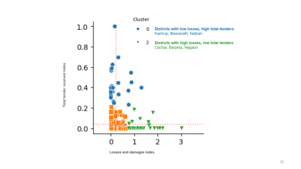
- Enabled data-driven planning for SDRF disbursements in Assam, where 95% of the flood budget was allocated to the six most vulnerable districts identified by IDS-DRR.
- Assisted in identifying gaps between flood-prone districts and resource allocation, improving alignment with ground realities.
Capacity Building:
- Trained over 250 decision-makers in Assam to integrate IDS-DRR into daily operations, with 97% of participants finding the tool intuitive and effective for project proposals.
Scalable Model:
- Consolidated and standardised 38 datasets, providing reusable scripts for extraction and analysis.
- Shared outputs included flood hazard maps, vulnerability analyses, and disaster preparedness insights.
Outputs
- Trained over 250 senior decision-makers and field officers across 35 districts and 196 revenue circles in Assam to integrate IDS-DRR into daily operations.
- Shared 38 datasets (12-14 per target state) in public repositories, along with scripts for data extraction and transformation.
- Conducted a preliminary risk analysis focused on the Beas River in collaboration with Himachal Pradesh State Disaster Management Authority, which was shared with officials to validate the methodology.
Impact and Way Forward
The IDS-DRR platform has been operationalised in Assam, driving strategic flood-risk planning and resource allocation. It is being scaled to Himachal Pradesh, Odisha, Bihar, Uttar Pradesh, and Bangkok. Recognised by the UN’s FG-AI4NDM as a scalable case study, IDS-DRR is poised to enhance disaster preparedness globally.
Future plans include expanding the platform’s capabilities to integrate additional geographies and refining AI-driven public procurement analysis for better resilience planning.
Acknowledgements
Assam and Himachal Pradesh SDMAs, The Rockefeller Foundation, Patrick J. McGovern Foundation, J-PAL SA IDCA team, UN FG-AI4NDM.